Stage 1 – Pietrasanta/Valpromaro
km 19,7
elevation gain m 515
elevation loss m 400
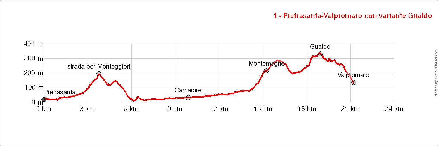
with variant Gualdo
km. 21,3
elevation gain m 655
elevation loss m 540
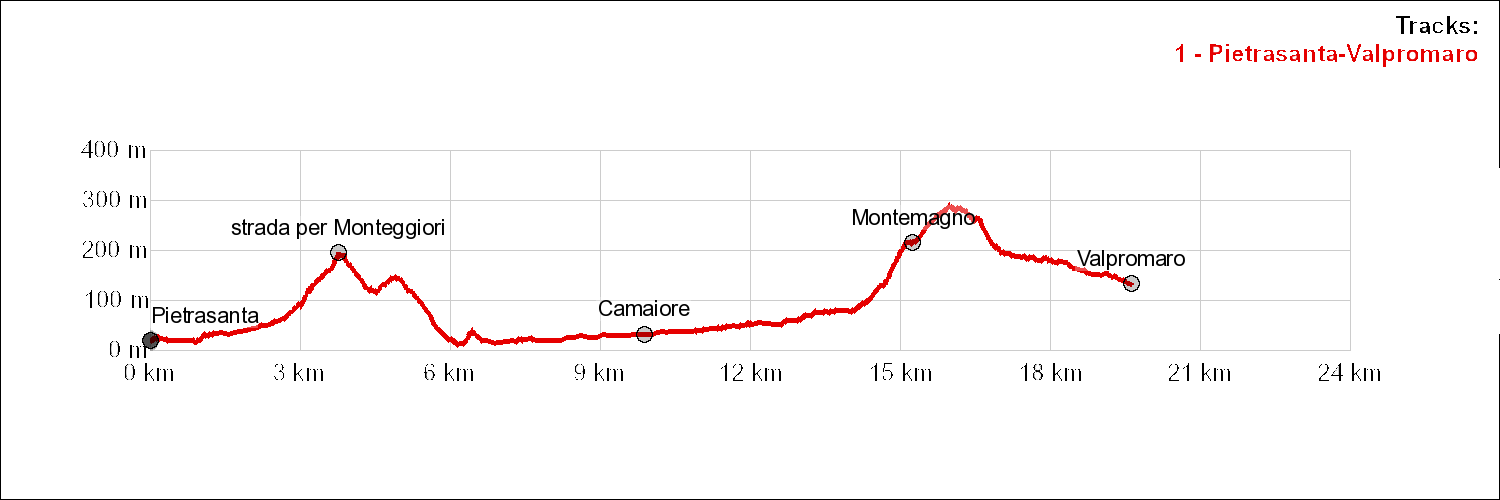
FIRST HALF STAGE – From Pietrasanta to Camaiore – km 10,6
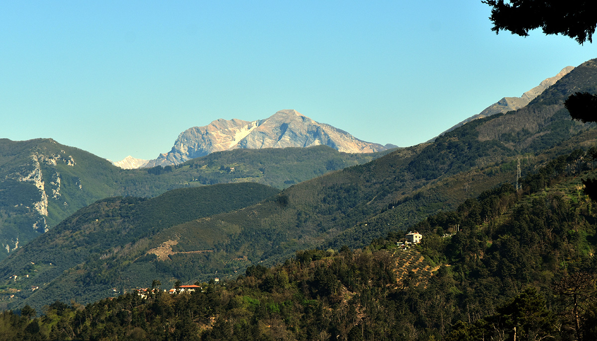
The stage takes place, except for a short stretch, in urbanized areas, mainly on asphalt. With the exception of the Pietrasanta exit, the roads traveled are of local interest. The path runs at the foot of the southern Apuan Alps, first crossing the territory of Valdicastello Carducci and then entering, with a steep but short climb, the territory of Camaiore. We reach the city by going up the banks of the river of the same name.
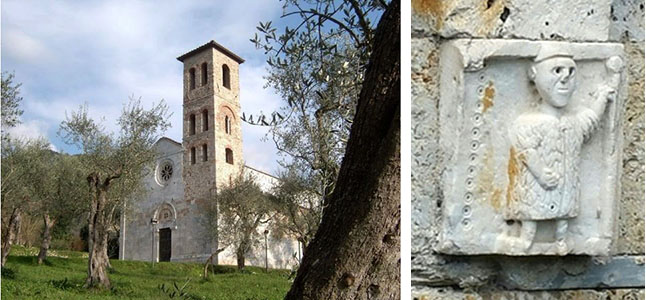
Our journey starts from the central and beautiful Piazza Duomo, the heart of Pietrasanta (km 0.0). We take via Garibaldi which takes us out of the historic center to the edge of the busy SP439 Sarzanese-Valdera; by a pedestrian crossing we move to the right side and walk along the cycle / pedestrian path until we reach the cemetery: here we find a road that goes left towards Valdicastello. Traffic is now significantly less. After 400 meters we pass by the ancient parish church of Saints John and Felicita: some blind arches are carved on the crowning ledge of the external side of the apse: in one a pilgrim is carved. After 1.4 km we meet a crossroads: we leave the main road and take the right branch until we reach the foot of the hill which we follow to the left for just 130 meters until we reach another intersection where Via Orticeto begins. On a slight slope we arrive at a timber sawmill.
A few meters later we take a path on the right that climbs to the bottom of a canal and which soon leads us to cross the hill (loc. Cannoreto, km 3.00). We go down immediately. After crossing a dense bamboo grove, we skirt the boundary of the Villa Le Pianore public park until we reach the plain. We continue on a series of narrow streets (via dell’Acquarella, via la Stretta, via Dietro Monte) with a winding but substantially flat path flowing at the foot of the hill: scattered houses, fields and vegetable gardens here and there. After a short climb we return to the flat: be careful not to lose the indication of a sharp left turn that takes us to an asphalt cycle path.
Finally we arrive near the busy SP1 “Francigena”, which we will cross several times in the rest of the stage. We walk along a small road that runs parallel to the provincial road: after 200 meters we notice the pedestrian bridge that crosses the Camaiore river. We cross the provincial road, cross the bridge and take a pleasant and quiet cycle-pedestrian path on the left. At the end, another pedestrian bridge takes us back to the provincial road that we cross heading towards the historic center. We can follow the red and white stripes that indicate the path of the Via Francigena: it is better, however, to reach Piazza XXIX Maggio and take the central and beautiful Via Vittorio Emanuele that crosses the historic center up to the east gate of Camaiore (km 10,5).
SECOND HALF STAGE – From Camaiore to Valpromaro – km 9,1
We leave Camaiore and go up the valley floor for a long time that leads us to Montemagno: we walk along the profile of the hill and then descend into the Valfreddana up to Valpromaro. We can also choose, by lengthening the path a little, the beautiful route that passes through the village of Gualdo
Leaving the historic center, we cross the roundabout and walk along Via Roma, which runs almost in a straight line; the road does not offer a comfortable pedestrian path: it is better to keep us on the right side. Finally we reach the SP1 Francigena and cross it; we pass a small bridge and follow a road to the left which then narrows, becomes pedestrianized and runs next to a sports area. Further on we pass next to a canal until we reach an asphalted road. We turn left and, just before entering the SP1, we follow a small road to the right that first runs straight, then bends to the right and reaches the edge of a hill that borders the valley. We walk along a path that initially slips along the edge of the wood with a nice path. Further on, it definitely enters the wood, flanked by a canal that served as a millstone for a nearby mill.
Finally, we go out onto an asphalted road: with a double bend, first to the left and then to the right, we go along a straight asphalt road that begins to climb: we are in Pontemazzori. We meet a beautiful cross of the passion, the first of a series that we will encounter frequently in the next few days, then an abandoned church: if we look out the front windows we can see a painting of the Holy Face of Lucca above the altar.
 Shortly after we reach the SP1 but a few meters later we leave it taking the ancient mule track to the right, recently covered, in the first section with a bottom of stones and concrete. After a water deposit, the original bottom returns. With a moderate slope, the mule track climbs up to Montemagno (15,3 km). Here begins the territory known as “the six miles”. On our right is a statue of Giorgio Gaber, who lived in a villa in Montemagno in the last years of his life. Arriving at a small square / parking lot, we turn right and walk it to the bottom, then starting to climb to the right on the hill above the town. The slope, initially sustained, gradually flattens out and takes us to a crossroads at the beginning of the village of Licetro. From this point we can enjoy a wide view over Versilia and even further up to the Gulf of La Spezia.
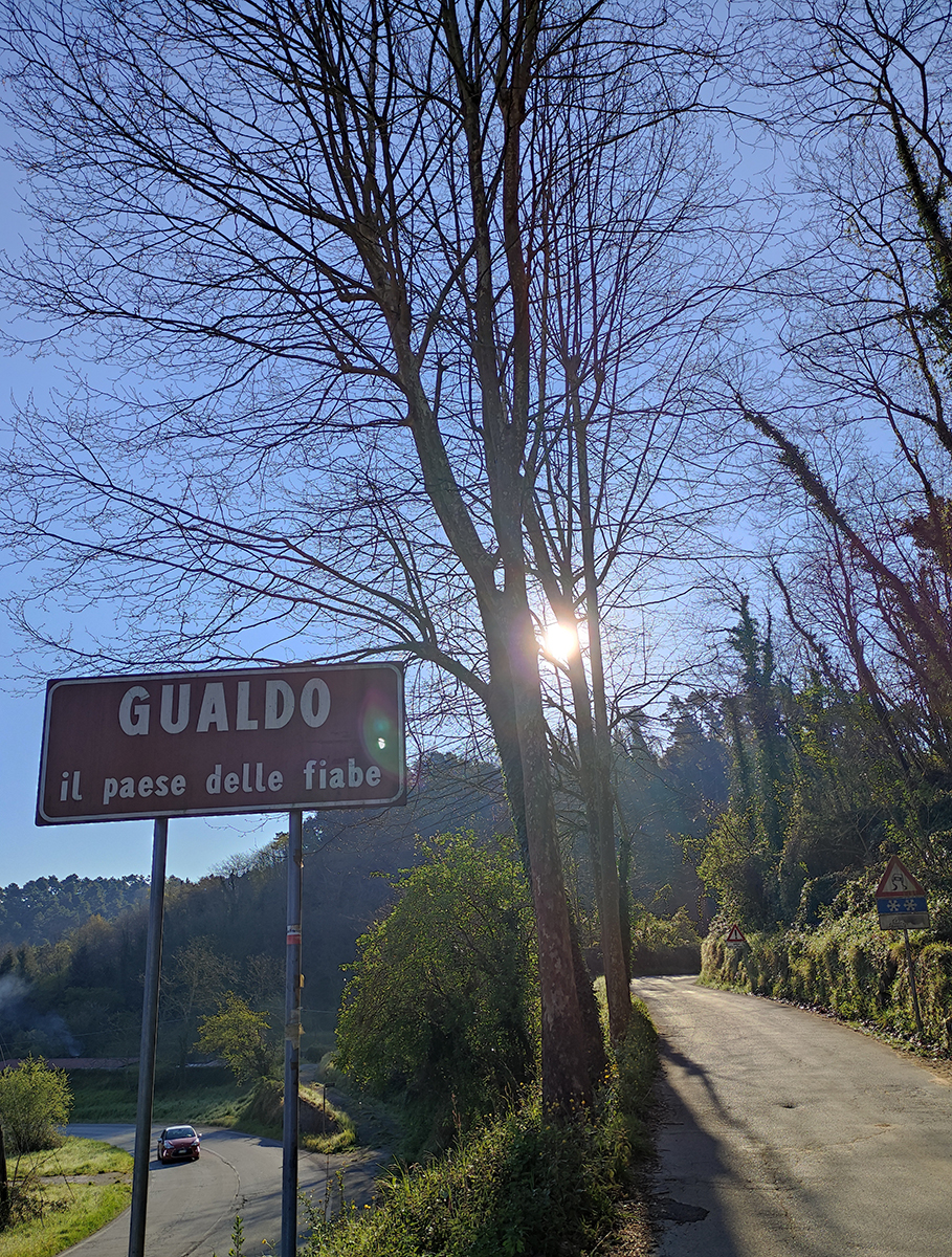
We turn right and take a path that cuts the side of the hill, always remaining on the sea side. Further on, the path becomes dirt and the slope becomes accentuated. We quickly arrive at the edge of the SP34 dei Campaniletti (km 17.1) .m On the other side of the road we see a large sign indicating two different paths to reach our end of the stage: a quick but not very beautiful one that runs along the provincial roads SP34 dei Campaniletti and SP1 Francigena; the other much more beautiful and almost all on a path but longer and more tiring that climbs to the village of Gualdo and then descends to Valpromaro. The second route is 2.6 km longer and has a greater uphill gradient of 150 m. We describe both routes.
ROUTE 1 – short way – We turn left and walk slightly downhill along the SP34 dei Campaniletti. We recommend going to the right side which allows you to walk some sections safely: there are two curves to go through carefully along the guardrail. The SP34 ends at the intersection with the SP1 coming from Camaiore. We follow it to the right taking advantage of some sections with pedestrian platforms: here too we recommend using the right side of the road. We meet a dirt road that branches off to the right, skirt a wood deposit and take the SP1 further ahead. Still slightly downhill we arrive at the beginning of the village of Valpromaro. We leave the provincial road and walk along the road along which the houses wind up until we reach the former rectory, now used as a hostel.
 ROUTE 2 – panoramic way – We go up the SP34 to the right for 200 meters and take the road on the left that leads to Gualdo. After 300 meters, at the height of a small bridge, we go down to the right on a small road that runs along a stream and which gently climbs the bottom of a valley until it turns sharply to the left and begins to climb with a steep slope using the steps obtained on the side. of the hill. It is a hard, albeit short, climb that begins to soften when we see some cultivated pitch: we are at the lowest houses in Gualdo. We go out onto a carriage road that we travel slightly uphill until we reach the entrance to the splendid village. We go up the steep streets that lead us to the church, which dominates the village from above: from the square in front you can enjoy a splendid view of the Camaiore valley, Versilia, the Gulf of La Spezia.
We go down a staircase on the road below until we find, a few meters away, the entrance to a dirt road which, by cutting the side of the hill overlooking the Val Freddana, takes us to Valpromaro. Much of the road winds on a slight slope which instead becomes sustained in the last part. We arrive in the village a few meters from the hostel (km 19,7).
services
PIETRASANTA
Hospitality San Francesco – inside the convent attached to the Church of San Francesco, a structure from the first half of the 1500s, in Via dei Frati, 10 minutes from the Piazza del Duomo. It has four three-bed rooms with en suite bathrooms and one three-bed room with a bathroom in the corridor. It does not have a kitchen and an agreement for affordable meals for pilgrims is being defined. Open from 12 June to 30 October. Hospitality by donation. Volunteers Phone: 353.4302467, Romina 389 5297667 Adriano 348 6001527 – sanfrancescopietrasanta@gmail.com
Diocesan House “La Rocca” – Via della Rocca, 10 – casarocca@tiscali.it tel. 0584.793094 – Religious structure of the Sisters of Our Lady of Sorrows, servants of Mary of Pisa – 1 dormitory for 6, bathroom and shower, no bed sheets, annual opening, € 20.
CAMAIORE
Municipal hostel of the Pellegrino, via Madonna della Pietà (historical center), tel. 345.1168661 (Grazia and Roberto), info@ostellodicamaiore.it, www. ostellodicamaiore.it, 24 seats, € 10 for pilgrims with credentials, annual opening. Access and room for disabled people.
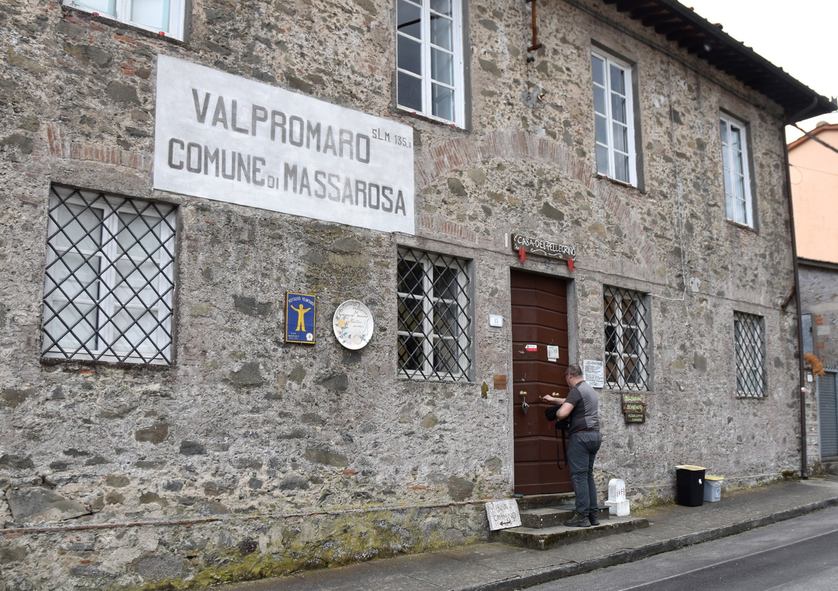
VALPROMARO
Casa del Pellegrino – parish hostel – Via Vecchia Provinciale, 236, Parish of San Martino, tel.0584.956028, valpromaro@gmail.com, Casa del Pellegrino Facebook page, on Via francigena, 35
beds, Wi.fi, bed sheets, blankets, bathrooms and showers, shared dinner, washing machine and dryer, place for bicycles and animals, possibility to pitch the tent in the garden, responsible donation. The structure is suitable to accommodate people with disabilities.
Pietrasanta
Trenitalia – Genoa-Pisa line
Bus line E43 CTT Lucca – Vaibus for Camaiore (stop at Capezzano Pianore)
Taxi – parking on the square in front of the train station.
Capezzano Pianore
Bus line E43 CTT Lucca – Vaibus for Camaiore or Pietrasanta.
Camaiore
Trenitalia – Genoa – Pisa line (local trains only – change at Massa) the station is about 4 km from the center.
us line E15 CTT Lucca – Vaibus for Montemagno> Valpromaro (stop in Piazza Romboni).
Montemagno
Bus line E15 CTT Lucca – Vaibus for Valpromaro – Lucca or for Camaiore.
Valpromaro
Bus line E15 CTT Lucca – Vaibus for Lucca or Camaiore.
Pharmacies: Pietrasanta, Camaiore, Valpromaro
Hospitals: Pietrasanta (a 6,5 km from the Versilian hospital center)
Bar: Pietrasanta, Camaiore, Montemagno, Valpromaro
Restaurants: Pietrasanta, Camaiore, Montemagno
Bank: Pietrasanta, Camaiore
Post Office: Pietrasanta, Camaiore, Valpromaro
Railway Station: Pietrasanta
Sports equipment: Pietrasanta, Camaiore
Food and Supermarket: Pietrasanta, Camaiore, Valpromaro
Mechanical assistance service for bicycles: Pietrasanta, Camaiore, Monte Magno
In case of necessity you can call, for the section between Pietrasanta and Camaiore:
– Daniela Bonucelli – 349.8814734
– Antonio Landucci – 339.5668841
while, for the stretch from Camaiore to Valpromaro, you can call the Valpromaro pilgrim reception. These are the contacts:
– Jacopo Menchetti – 347.2723288
– Mirco Lazzari – 347.8410569
– parish house / hostel: 0584.956028
places

Whoever arrives in Pietrasanta immediately grasps the aspect of elegant worldliness and a lively tourist town. It can rightly be considered the historical capital of Versilia and is one of the main areas of artistic processing of marble, extracted from the nearby Apuane alps.
The squares continuously host the exhibition of works of sculpture and contemporary art. The constant rotation of the works makes it an open-air museum.
Over time, the tradition in stone processing has determined the presence of many important artists who have settled and worked here. Also known as Little Athens, it saw the presence, among others, of Fernando Botero (still resident in the area) and Igor Mitoraj, whose works can be seen walking through the village.
A walk in the historic center of this town of medieval origins must include a visit to the Cathedral of San Martino, overlooking the beautiful square that exhibits valuable works inside and the Bell Tower, to climb which a surprising helical staircase was built. Near the Cathedral are the church and convent of San Francesco, built in the sixteenth century. with the beautiful cloister and the brick bell tower and a few steps from the new municipal hostel. In the stretch of Via Francigena that leads to the Duomo, don’t miss the small church of S. Antonio abate della misericordia, formerly the Hospital of San Biagio, inside which two great works by Botero are visible: Hell and Paradise.
Marina di Pietrasanta is about three kilometers from the center and can be reached by a pleasant cycle-pedestrian path allowing you to enjoy the beach and the splendid sea. In the hamlet of Valdicastello is the birthplace of the poet Giosuè Carducci, now transformed into a house-museum dedicated to the memory of the poet.
For more information: https://it.wikipedia.org/wiki/Pietrasanta
 This village located on the Via Francigena was formerly an area rich in timber, pastures and above all fish ponds: small marshy waterways that were used for navigation and fishing. An area particularly suited to the cultivation of vines and olives within which the remains of a Roman rustic villa have recently been discovered, superimposed on a pre-existing Etruscan site. There is the Villa Borbone delle Pianore, which dates back to the 18th century. It was purchased in the first half of the nineteenth century by Maria Teresa of Savoy, Duchess of Lucca, and here was born in 1892 Zita di Borbone-Parma, the last empress of Austria, wife of Archduke Charles of Habsburg-Lorraine.
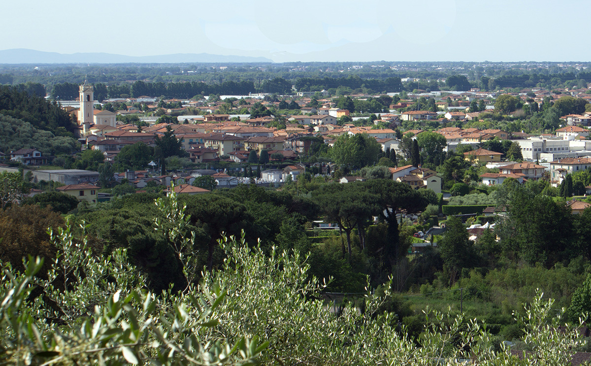
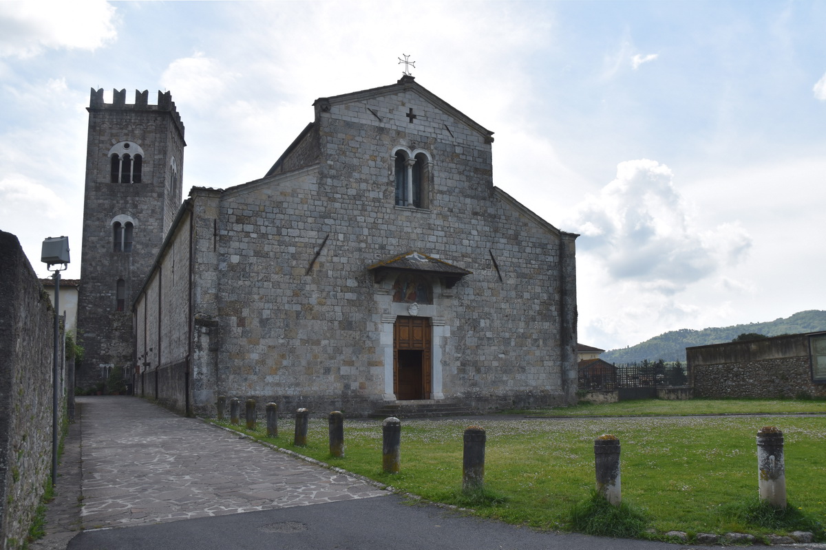 Campus Major was the name with which the ancient Romans defined the wide plain that stretched between Lucca and the ancient port of Luni. From here the town takes its present name which was later a Longobard dominion, then a possession of the Lords of Lucca until the Renaissance. It remained under the dominion of the Sforza until 1799, when it fell into the hands of the Napoleonic troops. It is located in a large basin at the foot of the Apuan Alps and today it is easy to retrace its history by walking in its historic center, among the beautiful noble palaces and vestiges of the past such as the Collegiate Church of Santa Maria Assunta, with a Latin cross plan, the Church and the beautiful cloister of San Lazzaro, the sober Badia di San Pietro, founded by the Lombards around the eighth century, once an important monastic complex: it is worth a visit; some spaces have been renovated and used as a hostel. The seat of the interesting archaeological museum is located in the Palazzo Tori Massoni. It is also worth mentioning the Museum of Sacred Art where paintings, furnishings and sacred vestments dating back to the fourteenth and sixteenth centuries are kept. A handful of kilometers connects Camaiore to its renowned Lido, home to beautiful beaches and great liveliness. Worth noting is the ancient tradition that takes place in June, on the occasion of the Corpus Domini procession, which sees the historic center filled with sawdust carpets, called “pula”. A group of “tappetari” (who make carpets) creates amazing figurative works up to forty meters long for the occasion, coloring the whole city.
For more information: https://it.wikipedia.org/wiki/Camaiore
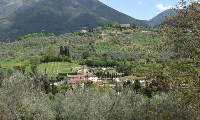
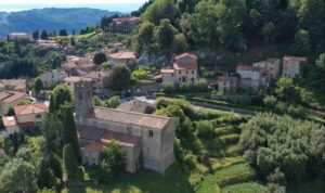
It’s a small village enclosed around the church and crossed by the road leading to Lucca, inhabited by a lively community. There is a medieval castle which is an example for the Camaiore area of a noble residence and at the same time a refuge in case of siege. From this hill you can enjoy a vast panorama of Versilia. In the autumn of 2019, bad weather caused the fall of the monumental holm oak that was the landmark of the village, 8/900 years old. The plant was located near the statue in memory of Giorgio Gaber, (famous Italian artist) who had a house in Montemagno, visible from the path we are going to take, where he passed away at the age of 63. Near the Church of San Michele, the “Tenuta Mareli” biodynamic farm produces excellent wines to accompany, with appropriate moderation, the pilgrims’ dinner.
Gualdo is located a short distance from Valpromaro. You pass through it if you take the beautiful variant or you can reach it with a short walk. It is a small village that preserves its medieval structure intact. Its name derives from the Saxon “Waldum” which means “privileged forest”. The old houses are made of stone, with small windows and the balconies are embellished with the lively color of the flowers. It was a border area between two great powers who around the year 1000 competed for the areas behind the lake of Massaciuccoli: the Montemagni, lords of Montemagno and allied with Pisa, and the Canons of San Martino di Lucca, owners of a long estate which went from Massarosa to the Freddana stream, allies of Lucca.
In the village, every year, in the second half of August, the “Fairy Tale Festival” is held: for two days there are entertainment shows, workshops for children, street artists and acrobats; you can come across the mischievous goblin Buffardello, or the wild Omo and even the Sirens of Viareggio, who came out of the sea, and other fantastic characters. For the snack, scones and panucciori baked directly from the ancient ovens of the village, another notable element of tradition.
The small village is crossed by the Via Francigena and is administratively located on one side in the municipality of Massarosa and on the other in the municipality of Camaiore. It offers various services but above all the warmth and open friendship of the villagers. The Pilgrim’s Home named after Giuseppe Mancino, one of the oldest accommodation facilities along the Francigena, avails itself of the collaboration of the Pilgrim Hospitality Hospitallers, a branch of the Spanish organization Hospitaleros Voluntarios. The volunteers of the country with the help of the Hospitallers manage the reception activity without receiving any compensation in the face of a free offer, thus relying on the generosity of today’s pilgrims in order to guarantee the welcome to those of tomorrow.
along the way
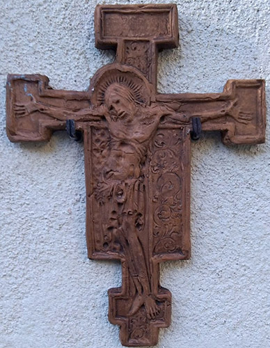
In 2019 Marco, from Montemagno, found a small terracotta cross abandoned and reduced to pieces: it is made using the Crucifix by Cimabue as a model, housed in the Basilica of Santa Croce in Florence, damaged during the flood of November 4, 1966.
Marco restores it, turns it into a “rubber” and with this system reproduces it in terracotta in various specimens that are blessed in the church of San Pantaleone in Pieve a Elici. Marco decides to donate a copy to those who intend to exhibit it in public places, preferably in places of walk and pilgrimage. A copy is located in the hostels of Pietrasanta, Badia Pozzeveri, San Miniato; in the Shambala refuges in the Giumello Alps and Grandi Adamoli in Varese, in Prati di Tivo (Teramo); in the French consulate in Naples; in the churches of San Pellegrino in Alpi, in Casargo (Lecco); in a French community in New Caledonia and in a Catholic community in Canton Ticino, Switzerland.
If anyone intends to exhibit it in public places, make a request to Marco: marcomorotti60@libero.it
On Youtube there is the video of the blessing of the cross in the Valpromaro hostel: https://www.youtube.com/watch?v=a51errFnJ30

The “majesty” is a marble artefact in white Apuan marble – mostly in relief but, in smaller numbers, also in the form of a small statue and marginally in the form of a wall painting – which is found in the territory of the Historic Lunigiana: province of Massa , La Spezia, west side of Lucca, Parma and Reggio Apennines. They are at the edge of the streets, in newsstands or small chapels, on the walls of the houses, above the portals of ancient villages. However in a public place and always on important or main transit routes for roads, paths and mule tracks where they can be visible and recognizable. They are also often accompanied by the acronym P.S.D. – by him devotion (italian: Per Sua Devozione).
They were commissioned or purchased as a private act, attesting to the particular devotion of the family or of the person who had arranged for their location – together with its declared and recognizable economic availability. The majesties frequently bear the name of the buyer: it is found engraved at the base of the majesty or in a plaque below together with the dedication to the holy image represented and often also to the date.
The very choice of the sacred image to be proposed for worship often responds to criteria of opportunity and recognition: the client frequently chooses for himself or for his family an eponymous saint – that is with his own name – or at least evoking in the iconographic typology characteristics proper to the surname or profession to which they belong.
The spread of the majesties began in the second half of the 16th century: in the spirit of strong doctrinal stiffening following the Council of Trent (1545/1563), the Church intended to support Catholic orthodoxy following the Lutheran schism and therefore favored the placement of signs that affirmed the devotion of the population.
With the prevalent use of white Apuan marble, sculpted by local stone-cutters, whose name is almost never known, and transported by mule everywhere by street vendors – from the coast to the Apennine passes – the majesties remain recognizable. as such until the early decades of the twentieth century.
In upper Versilia they are called “marginette”; in Garfagnana “m (a) estatine”.
For more information: www.lemaesta.it
Gombitelli is known as a linguistic island and its dialect, now almost completely out of use, had Gallo-Romanesque, Lombard, Piedmontese and Emilian words. Several hypotheses have been put forward to explain the phenomenon.
In the sixteenth century some German blacksmiths, following the emperor Charles V, decided to stop in the village on the hills of Camaiore: they then started the manufacture of nails, called “gavorchi” (which in the Lucca dialect means something ugly, ungainly), as they were used for carpentry and were not well finished. According to other sources, the origin is to be found in the arrival of populations from Northern Italy in the 15th century to work iron. Another source mentions that the dialect was brought in 1442 by groups of people from Villa Minozzo. while still another reports that the inhabitants (even in this source the inhabitants were mostly dedicated to metalworking) from Northern Italy came from the Bergamo area.
Today, the remains of this work can be found in the walls of the houses, because the waste from the iron work was used as a filling for lime and mortar. (from Wikipedia)
See also https://www.intoscana.it/it/dettaglio-video/e-via-andare-gombitelli/
The area of the Six Miles consisted of all the countryside around the walls of the city of Lucca and up to six miles away.
This privilege originated in 1084 when Emperor Henry IV decreed the freedom of these territories from the Marca di Tuscia and direct subjection to the emperor himself. On this area it was not allowed to erect any castle or fortification building, thus favoring the self-government of the Free Municipality of Lucca which, since then, will begin to oppose the neighboring feudal families with increasing determination, ensuring dominion over large territories, to clash, for hegemony in Tuscany, with the Municipality of Florence.
The government of this large territorial dimension made Lucca a thriving municipality, being able to impose taxes and duties on agricultural and productive activities. In fact, the Emperor Henry IV made a direct agreement with the community of the citizens of Lucca, granting them some guarantees in judicial matters. The ban on the construction of fortified structures kept the municipality free from the aims of some noble families who could have threatened the access roads to the urban center or subjected the inhabitants to impositions and harassment.
At the beginning of the 14th century, after the upheavals caused by the struggles between white and black Guelphs, Lucca was conquered by Uguccione della Faggiola who had Castruccio Castracani, a noble of Lucca origin, at his side as imperial vicar. Later in a popular uprising the people of Lucca overthrew the oppressive government of Uguccione and acclaimed Castruccio as captain of the people. With the lordship of Castruccio Castracani the municipality reached its maximum power and extension: its territories included the Garfagnana to the north, the coast from the city of Carrara to Pisa to the west, the city of Pistoia to the east (under the condominium of Lucca and Florence), to the south the Arno Valley, albeit constantly disputed with the Republic of Florence. This commemorates the major conflict that occurred in the battle of Altopascio, at the end of which the defeated Florentine army was chased up to the walls of Florence.
The following municipalities are defined as the six Camaiore miles: Montemagno, Gombitelli, Migliano, Valpromaro, Fibbiano, Santa Maria Albiano, Orbicciano and Fibbialla. These villages, each with its own characteristics, are united by different aspects such as traditions, cuisine, dialect (apart from the linguistic island of Gombitelli). For the more precise, it should be noted that these are Roman miles for which one mile equals 1.48 km and therefore six miles equals 8.88 km.